Active Transportation through Highway 417 Interchanges: Richmond Road, Pinecrest/Greenbank Road, Woodroffe Avenue, and Maitland Avenue
This project is a City of Ottawa initiative to complete functional designs for new walking and cycling connections through four Highway 417 interchanges (Richmond, Pinecrest/Greenbank, Woodroffe, and Maitland), tying into new bridges over the Highway which are being advanced separately and in advance by the province. The project aims to close major gaps in the active transportation network by safely connecting neighbourhoods and transit across Highway 417, while maintaining existing traffic operations.
For more project updates and information, please see below. We also encourage participating in our survey to help inform the project.
This project is a City of Ottawa initiative to complete functional designs for new walking and cycling connections through four Highway 417 interchanges (Richmond, Pinecrest/Greenbank, Woodroffe, and Maitland), tying into new bridges over the Highway which are being advanced separately and in advance by the province. The project aims to close major gaps in the active transportation network by safely connecting neighbourhoods and transit across Highway 417, while maintaining existing traffic operations.
For more project updates and information, please see below. We also encourage participating in our survey to help inform the project.
-
Planning Context
Share Planning Context on Facebook Share Planning Context on Twitter Share Planning Context on Linkedin Email Planning Context linkHighway 417 is a critical east-west corridor for moving people and goods across Ottawa. However, while it connects the city for drivers, it also creates a significant barrier for walking and cycling by limiting safe and comfortable north-south connections between nearby neighbourhoods, transit stations, schools, parks, and other community destinations. Today, travelling through Highway 417 interchanges at Richmond Road, Pinecrest/Greenbank Road, Woodroffe Avenue, and Maitland Avenue can be difficult for people walking and cycling due to limited facilities, indirect routes, high-speed traffic, and complex ramp configurations. These conditions make even short local trips uncomfortable forContinue reading
Highway 417 is a critical east-west corridor for moving people and goods across Ottawa. However, while it connects the city for drivers, it also creates a significant barrier for walking and cycling by limiting safe and comfortable north-south connections between nearby neighbourhoods, transit stations, schools, parks, and other community destinations. Today, travelling through Highway 417 interchanges at Richmond Road, Pinecrest/Greenbank Road, Woodroffe Avenue, and Maitland Avenue can be difficult for people walking and cycling due to limited facilities, indirect routes, high-speed traffic, and complex ramp configurations. These conditions make even short local trips uncomfortable for many users and inaccessible for others.
In 2018, the City completed the Queensway Pedestrian and Cycling Connections Study which identified priority opportunities to improve active transportation (walking and cycling) connections across Highway 417. This work focused on enhancing access to transit stations delivered as part of the Stage 2 LRT West Extension, as well as improving connections between surrounding communities.
Following the recommendations of the 2018 Queensway Pedestrian and Cycling Connections Study, active transportation improvements across the Richmond Road, Pinecrest/Greenbank Road, Woodroffe Avenue, and Maitland Avenue interchanges with Highway 417 were included as First Phase projects in the City’s Transportation Master Plan (TMP).
The Ministry of Transportation Ontario (MTO) is currently advancing bridge replacements where Richmond Road, Pinecrest/Greenbank Road, Woodroffe Avenue, and Maitland Avenue cross over Highway 417. As part of this work, MTO will include new walking and cycling facilities across the bridge structures themselves. However, the scope of the provincial project is limited to the bridges and does not include the adjacent connections needed to link these facilities into surrounding neighbourhoods and pathway networks. Additional information related to this bridge replacement project can be found on the Provincial Project Website.
To complete these connections and realize the full benefit of the new bridges, the City is advancing this functional design project for the connecting active transportation facilities through the four interchanges. The functional designs presented on this website establish the proposed layouts and future walking and cycling connections that will guide subsequent detailed design and future implementation.
-
Project Details
Share Project Details on Facebook Share Project Details on Twitter Share Project Details on Linkedin Email Project Details linkThis functional design project proposes new and enhanced walking and cycling connections through four Highway 417 interchanges in Ottawa’s urban west end. The designs are coordinated with bridge replacements being delivered by the Province in advance of the City’s project. They focus on creating safe, direct, and continuous routes that connect communities, transit, and existing pathway networks, while supporting long-term corridor improvements aligned with the City’s Complete Streets Policy.
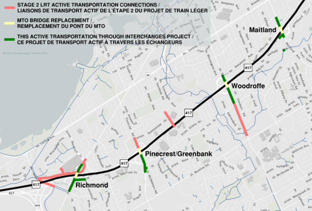
Figure 1: Key Plan
Richmond Road Interchange
Proposed Design Elements:
Barrier-protected multi-use pathway on the east side Continue reading
This functional design project proposes new and enhanced walking and cycling connections through four Highway 417 interchanges in Ottawa’s urban west end. The designs are coordinated with bridge replacements being delivered by the Province in advance of the City’s project. They focus on creating safe, direct, and continuous routes that connect communities, transit, and existing pathway networks, while supporting long-term corridor improvements aligned with the City’s Complete Streets Policy.

Figure 1: Key Plan
Richmond Road Interchange
Proposed Design Elements:
Barrier-protected multi-use pathway on the east side of the road, extending the facilities on MTO’s new bridge south to the Holly Acres/Nanaimo Drive intersection and north to the Bayshore Drive intersection
New multi-use pathway connection through Mohawk Park linking Richmond Road to Queensline Drive
Overall Connectivity:
O-Train Line 3 (Bayshore Station)
Planned cycling and pedestrian facilities on Richmond Road north of the interchange toward Pinecrest Road, providing access to the Bayshore neighbourhood
Direct connections south of the interchange to the Qualicum-Redwood neighbourhood, existing multi-use pathways on Holly Acres Road, and existing paved shoulders on Richmond Road
Pinecrest/Greenbank Road Interchange
Proposed Design Elements:
Bidirectional cycle track and sidewalk on the west side of Greenbank Road, extending the facilities on MTO’s new bridge south through the Iris Street/south ramp terminal intersection and improving connections to Morrison Drive and to McWatters/Stanton Road
Overall Connectivity:
Planned cycling and pedestrian facilities north of the interchange to Queensview Drive, providing access to O-Train Line 3 (Pinecrest Station) and the Bayshore and Queensway Terrace North neighbourhoods
Direct connections south of the interchange to the Qualicum-Redwood and Iris neighbourhoods
Woodroffe Avenue Interchange
Proposed Design Elements:
Sidewalks and unidirectional cycle tracks on both sides of Woodroffe Avenue, extending the facilities on MTO’s new bridge through both ramp terminal intersections and south to Iris Street
Overall Connectivity:
Direct connection north of the interchange to the existing multi-use pathway to Benjamin Avenue, providing access to the Glabar Park, Whitehaven, and Woodpark neighbourhoods
Planned protected intersection at Woodroffe Avenue and Iris Street south of the interchange, providing access to O-Train Line 1 (Iris Station), the Pinecrest Creek Pathway, and Braemar Park, Bel Air Heights, and Copeland Park neighbourhoods
Maitland Avenue Interchange
Proposed Design Elements:
Sidewalks and unidirectional cycle tracks on both sides of Maitland Avenue, extending the facilities on MTO’s new bridge through both ramp terminal intersections
New multi-use pathway connection between the south ramp terminal intersection and Riddell Avenue South, including a short link to the Experimental Farm Pathway near Garfield Avenue
Sidewalk and unidirectional southbound cycle track on the west side of Maitland Avenue between Lenester Avenue and the north ramp terminal intersection
Overall Connectivity:
Direct connections south of the interchange to the Experimental Farm Pathway and Braemar Park, Bel Air Heights, and Copeland Park neighbourhoods
Direct connections north of the interchange from Lenester Avenue and the existing multi-use pathway to Rex Avenue, providing access to the Laurentian, Whitehaven, Woodpark, and Glabar Park neighbourhoods
Highway Ramp Crossing Treatments
Improving safety, comfort, and accessibility where cycling and pedestrian facilities cross highway ramps is a key priority identified through public feedback and technical analysis.
The designs shown at this stage include a range of potential crossing treatments applied to each location, taking into account traffic speeds, volumes, and overall user safety. These concepts are informed by City and provincial guidance and will continue to be refined through future detailed design work prior to implementation.
Final ramp crossing designs will be developed in close coordination with MTO during the next phase of design. At that stage, treatments will be reviewed against emerging industry best practices and applicable provincial standards. The goal is to achieve the safest and most comfortable solution possible within applicable provincial requirements.
Motor Vehicle Traffic Impacts
This project is designed to improve safety for all road users while maintaining how the road network functions for drivers. No existing traffic lanes are being removed by this project, and overall traffic operations will remain similar to today. Some intersection changes, including new protected signal phases that improve safety for all users, may introduce minor delays for certain movements; however, detailed traffic analysis confirms these impacts are limited, well managed through signal timing, and within the City’s acceptable performance levels. Off-ramp queues will remain within available storage and are not expected to back up onto the mainline lanes of Highway 417.
-
Project Implementation - A Phased Approach
Share Project Implementation - A Phased Approach on Facebook Share Project Implementation - A Phased Approach on Twitter Share Project Implementation - A Phased Approach on Linkedin Email Project Implementation - A Phased Approach linkThe project is currently completing the functional design phase. Functional designs establish the overall layout and general approach for each interchange, to be confirmed and refined through a future detailed design process prior to construction.
Implementation of these overall interchange improvements will occur in phases. First, MTO will complete the bridge replacements, which will include the necessary walking and cycling facilities across the new structures. Following MTO’s bridge project, the City will tie-in to the new facilities on the bridges and deliver the active transportation connections through the rest ofContinue reading
The project is currently completing the functional design phase. Functional designs establish the overall layout and general approach for each interchange, to be confirmed and refined through a future detailed design process prior to construction.
Implementation of these overall interchange improvements will occur in phases. First, MTO will complete the bridge replacements, which will include the necessary walking and cycling facilities across the new structures. Following MTO’s bridge project, the City will tie-in to the new facilities on the bridges and deliver the active transportation connections through the rest of the interchange to adjacent communities.
Following completion of the functional design phase, the City’s priority is to advance the Maitland Avenue and Pinecrest/Greenbank Road interchange connections first, with the goal of implementing these improvements as soon as possible following completion of MTO’s bridge replacements. The Richmond Road and Woodroffe Avenue interchange functional designs will be retained as design-ready plans and implemented at a later date based on funding availability, future needs, or coordination with potential Highway 417 widening projects.
-
Upcoming Public Consultation
Share Upcoming Public Consultation on Facebook Share Upcoming Public Consultation on Twitter Share Upcoming Public Consultation on Linkedin Email Upcoming Public Consultation linkInterested members of the public are invited to attend an in-person public consultation session:
Date: Wednesday June 10th, 2026
Time: 6:30 PM – 8:30 PM
Location: The Chamber – Ben Franklin Place (101 Centrepointe Drive)
At the session, City staff will present the proposed functional designs and answer questions. Display boards and roll plans will be available for review, and a brief presentation will be provided at 7:00 PM.
Public consultation material will be posted to the project website following the session. Feedback received through the consultation process will help inform refinement of the functional designs prior to finalization.
Comments and questions can be submitted to the City project manager:
Andrew Eagen, P.Eng.
Senior Project Manager, Sustainable Transportation (A)
Planning, Development, and Building Services Department | City of Ottawa

andrew.eagen@ottawa.ca
Interested members of the public are invited to attend an in-person public consultation session:
Date: Wednesday June 10th, 2026
Time: 6:30 PM – 8:30 PM
Location: The Chamber – Ben Franklin Place (101 Centrepointe Drive)
At the session, City staff will present the proposed functional designs and answer questions. Display boards and roll plans will be available for review, and a brief presentation will be provided at 7:00 PM.
Public consultation material will be posted to the project website following the session. Feedback received through the consultation process will help inform refinement of the functional designs prior to finalization.
Comments and questions can be submitted to the City project manager:
Andrew Eagen, P.Eng.
Senior Project Manager, Sustainable Transportation (A)
Planning, Development, and Building Services Department | City of Ottawa
andrew.eagen@ottawa.ca
Key Dates
-
June 15 2026