Project Details
This functional design project proposes new and enhanced walking and cycling connections through four Highway 417 interchanges in Ottawa’s urban west end. The designs are coordinated with bridge replacements being delivered by the Province in advance of the City’s project. They focus on creating safe, direct, and continuous routes that connect communities, transit, and existing pathway networks, while supporting long-term corridor improvements aligned with the City’s Complete Streets Policy.
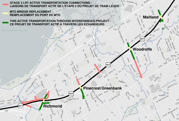
Figure 1: Key Plan
Richmond Road Interchange
Proposed Design Elements:
Barrier-protected multi-use pathway on the east side of the road, extending the facilities on MTO’s new bridge south to the Holly Acres/Nanaimo Drive intersection and north to the Bayshore Drive intersection
New multi-use pathway connection through Mohawk Park linking Richmond Road to Queensline Drive
Overall Connectivity:
O-Train Line 3 (Bayshore Station)
Planned cycling and pedestrian facilities on Richmond Road north of the interchange toward Pinecrest Road, providing access to the Bayshore neighbourhood
Direct connections south of the interchange to the Qualicum-Redwood neighbourhood, existing multi-use pathways on Holly Acres Road, and existing paved shoulders on Richmond Road
Pinecrest/Greenbank Road Interchange
Proposed Design Elements:
Bidirectional cycle track and sidewalk on the west side of Greenbank Road, extending the facilities on MTO’s new bridge south through the Iris Street/south ramp terminal intersection and improving connections to Morrison Drive and to McWatters/Stanton Road
Overall Connectivity:
Planned cycling and pedestrian facilities north of the interchange to Queensview Drive, providing access to O-Train Line 3 (Pinecrest Station) and the Bayshore and Queensway Terrace North neighbourhoods
Direct connections south of the interchange to the Qualicum-Redwood and Iris neighbourhoods
Woodroffe Avenue Interchange
Proposed Design Elements:
Sidewalks and unidirectional cycle tracks on both sides of Woodroffe Avenue, extending the facilities on MTO’s new bridge through both ramp terminal intersections and south to Iris Street
Overall Connectivity:
Direct connection north of the interchange to the existing multi-use pathway to Benjamin Avenue, providing access to the Glabar Park, Whitehaven, and Woodpark neighbourhoods
Planned protected intersection at Woodroffe Avenue and Iris Street south of the interchange, providing access to O-Train Line 1 (Iris Station), the Pinecrest Creek Pathway, and Braemar Park, Bel Air Heights, and Copeland Park neighbourhoods
Maitland Avenue Interchange
Proposed Design Elements:
Sidewalks and unidirectional cycle tracks on both sides of Maitland Avenue, extending the facilities on MTO’s new bridge through both ramp terminal intersections
New multi-use pathway connection between the south ramp terminal intersection and Riddell Avenue South, including a short link to the Experimental Farm Pathway near Garfield Avenue
Sidewalk and unidirectional southbound cycle track on the west side of Maitland Avenue between Lenester Avenue and the north ramp terminal intersection
Overall Connectivity:
Direct connections south of the interchange to the Experimental Farm Pathway and Braemar Park, Bel Air Heights, and Copeland Park neighbourhoods
Direct connections north of the interchange from Lenester Avenue and the existing multi-use pathway to Rex Avenue, providing access to the Laurentian, Whitehaven, Woodpark, and Glabar Park neighbourhoods
Highway Ramp Crossing Treatments
Improving safety, comfort, and accessibility where cycling and pedestrian facilities cross highway ramps is a key priority identified through public feedback and technical analysis.
The designs shown at this stage include a range of potential crossing treatments applied to each location, taking into account traffic speeds, volumes, and overall user safety. These concepts are informed by City and provincial guidance and will continue to be refined through future detailed design work prior to implementation.
Final ramp crossing designs will be developed in close coordination with MTO during the next phase of design. At that stage, treatments will be reviewed against emerging industry best practices and applicable provincial standards. The goal is to achieve the safest and most comfortable solution possible within applicable provincial requirements.
Motor Vehicle Traffic Impacts
This project is designed to improve safety for all road users while maintaining how the road network functions for drivers. No existing traffic lanes are being removed by this project, and overall traffic operations will remain similar to today. Some intersection changes, including new protected signal phases that improve safety for all users, may introduce minor delays for certain movements; however, detailed traffic analysis confirms these impacts are limited, well managed through signal timing, and within the City’s acceptable performance levels. Off-ramp queues will remain within available storage and are not expected to back up onto the mainline lanes of Highway 417.

Thank you for your contribution!
Help us reach out to more people in the community
Share this with family and friends