Rockdale Road – Traffic Calming and Urbanization

Share Rockdale Road – Traffic Calming and Urbanization on Facebook Share Rockdale Road – Traffic Calming and Urbanization on X (formerly Twitter) Share Rockdale Road – Traffic Calming and Urbanization on Linkedin Email Rockdale Road – Traffic Calming and Urbanization link

Project Overview

To improve safety for all road users and address vehicle speeds on Rockdale Road, the City is in the early stages of reviewing existing conditions and identifying potential improvements.

As part of this process, the City is considering and assessing the feasibility of a range of measures along Rockdale Road between Devine Road and Forced Road. These may include traffic calming measures, roadway design changes, and opportunities to enhance pedestrian crossings and overall safety for vulnerable road users. Improvements will be evaluated along segments of the roadway as well as at key intersections such as Rockdale Road and Buckland Road.
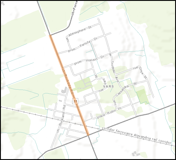

Map of project area


Local Context

Rockdale Road is a rural collector road that provides connectivity between the local and arterial road network and serves an important main street function for the Village of Vars. The project area extends along Rockdale Road from Devine Road to Forced Road for traffic calming measures, and from Devine Road to Buckland Road for urbanization improvements.

The Rockdale Road corridor currently has limited pedestrian and cycling infrastructure: there are no dedicated cycling facilities, and there are limited opportunities for pedestrians to travel safely along or across the roadway. Residents have identified concerns related to high vehicle speeds, pedestrian safety, and the need for improved connections for people walking, cycling, and accessing transit.

As part of the Transportation Master Plan, Rockdale Road from Devine Road to Buckland Road has been identified as a future Complete Street / Road Urbanization project. The City is studying opportunities to transform the corridor into a safer and more comfortable street by adding active transportation facilities, improving pedestrian crossings, and integrating traffic calming measures.


Policy Context

The City’s Transportation Master Plan identified projects that support complete street modifications to existing roads. These projects focus on reconfiguring roadways to better accommodate sustainable modes of transportation, provide access to available services and amenities, and encourage a shift toward walking, cycling, and transit.

As part of this, the plan also includes upgrading arterial and collector roads with rural cross-sections to more urban cross-sections that incorporate features such as sidewalks and cycling facilities. Rockdale Road has been identified as one of these priority projects.

This project aligns with the City’s goals of improving safety for all road users, reducing vehicle speeds, and creating a more complete and accessible roadway. The project is also consistent with the Consolidated Villages Secondary Plan, which includes objectives for improving Rockdale Road’s pedestrian connectivity and its role as a village main street.

Project Overview

To improve safety for all road users and address vehicle speeds on Rockdale Road, the City is in the early stages of reviewing existing conditions and identifying potential improvements.

As part of this process, the City is considering and assessing the feasibility of a range of measures along Rockdale Road between Devine Road and Forced Road. These may include traffic calming measures, roadway design changes, and opportunities to enhance pedestrian crossings and overall safety for vulnerable road users. Improvements will be evaluated along segments of the roadway as well as at key intersections such as Rockdale Road and Buckland Road.


Map of project area


Local Context

Rockdale Road is a rural collector road that provides connectivity between the local and arterial road network and serves an important main street function for the Village of Vars. The project area extends along Rockdale Road from Devine Road to Forced Road for traffic calming measures, and from Devine Road to Buckland Road for urbanization improvements.

The Rockdale Road corridor currently has limited pedestrian and cycling infrastructure: there are no dedicated cycling facilities, and there are limited opportunities for pedestrians to travel safely along or across the roadway. Residents have identified concerns related to high vehicle speeds, pedestrian safety, and the need for improved connections for people walking, cycling, and accessing transit.

As part of the Transportation Master Plan, Rockdale Road from Devine Road to Buckland Road has been identified as a future Complete Street / Road Urbanization project. The City is studying opportunities to transform the corridor into a safer and more comfortable street by adding active transportation facilities, improving pedestrian crossings, and integrating traffic calming measures.


Policy Context

The City’s Transportation Master Plan identified projects that support complete street modifications to existing roads. These projects focus on reconfiguring roadways to better accommodate sustainable modes of transportation, provide access to available services and amenities, and encourage a shift toward walking, cycling, and transit.

As part of this, the plan also includes upgrading arterial and collector roads with rural cross-sections to more urban cross-sections that incorporate features such as sidewalks and cycling facilities. Rockdale Road has been identified as one of these priority projects.

This project aligns with the City’s goals of improving safety for all road users, reducing vehicle speeds, and creating a more complete and accessible roadway. The project is also consistent with the Consolidated Villages Secondary Plan, which includes objectives for improving Rockdale Road’s pedestrian connectivity and its role as a village main street.

  • The City would like to hear your feedback on this project. This initial consultation is intended to gather input from the community to help identify key concerns and priorities within the project scope. Your feedback will help inform where efforts should be focused as the project moves forward.

    Take Survey
    Share Survey - Rockdale Road – Traffic Calming and Urbanization on Facebook Share Survey - Rockdale Road – Traffic Calming and Urbanization on X (formerly Twitter) Share Survey - Rockdale Road – Traffic Calming and Urbanization on Linkedin Email Survey - Rockdale Road – Traffic Calming and Urbanization link
Page last updated: 09 Jul 2026, 09:14 AM