Algonquin Station Secondary Plan
Purpose of the study
The purpose of this study is to prepare a new secondary plan that will guide private development and plan for future public infrastructure in the Algonquin Station area. With the arrival of the western extension of Line 1 of the O-Train, the City of Ottawa is conducting a long-range planning study to create new policies that ensure growth and development in this area are transit-supportive and advance the City’s housing, mobility, health, energy, climate and economic development objectives.
Study area
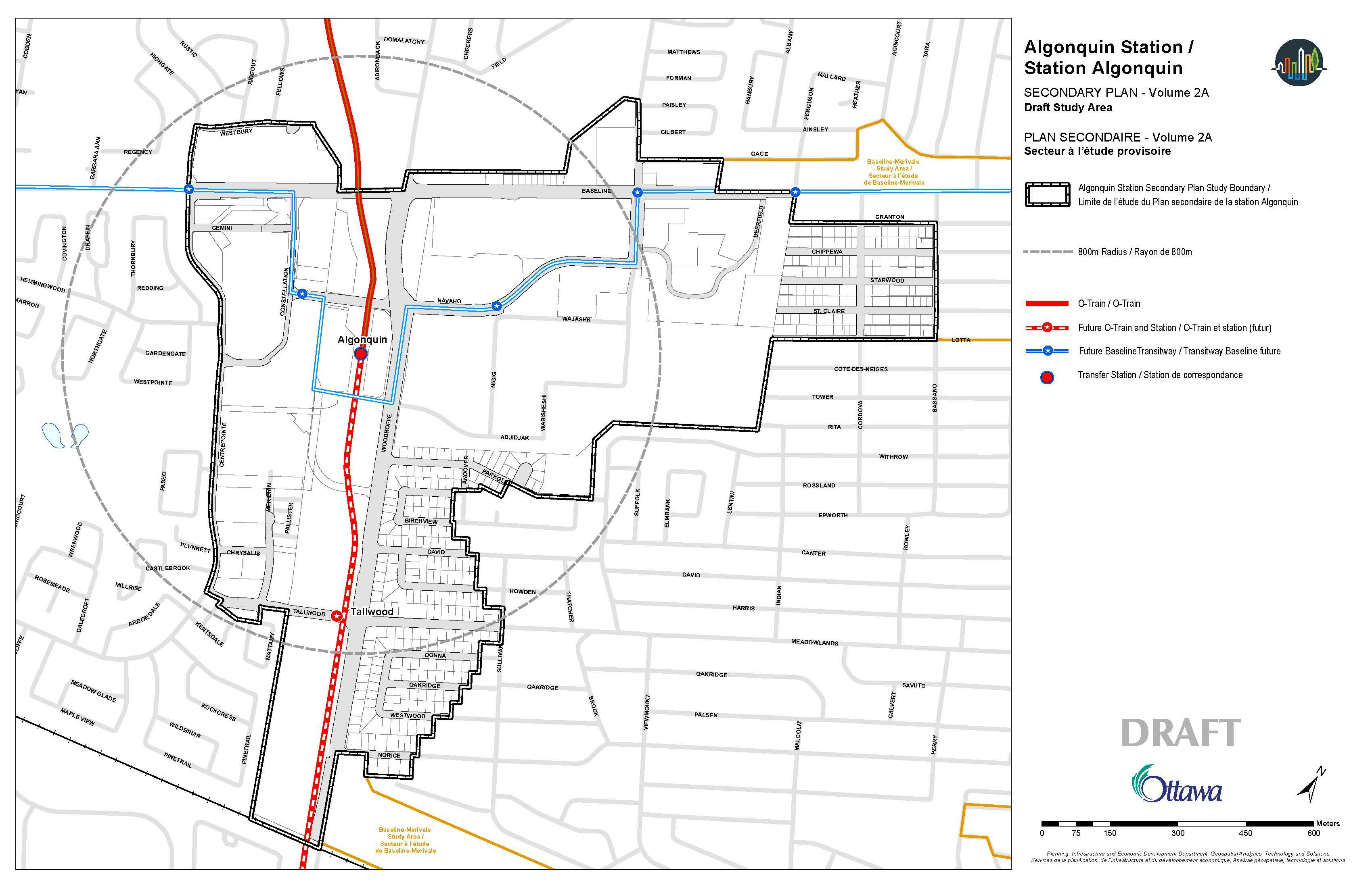
The Algonquin Station Secondary Plan study area is generally centered around the Algonquin O-Train Station and nearby segments of Baseline Road and Woodroffe Avenue. The study area boundary includes the Algonquin College Woodroffe campus, Sir Guy Carleton Secondary School, College Square shopping plaza, residential and commercial properties along Baseline Road, Woodroffe Avenue, Navaho Drive, Tallwood Drive, Constellation Drive, and Centrepointe Drive, as well as City of Ottawa parks and facilities.
The existing Baseline Station on the Transitway will be replaced with Algonquin Station once Line 1 of the O-Train is operational. Algonquin Station will be the terminus for Line 1 until such a time as the O-Train is extended to Barrhaven (subject to funding from other levels of government). The secondary plan study area includes five bus rapid transit stations of the future Baseline-Heron Transitway.
The study area, outline in black below, identifies the lands for which the secondary plan will apply.

What is a secondary plan?
A secondary plan is a long-range planning policy document that establishes the rules for growth, development, and infrastructure for an area anticipated to grow rapidly over the next 25 years.
A secondary plan takes a comprehensive look at a specific area to refine and modify direction from the City’s Official Plan to better fit the local context. A secondary plan may propose changes to allowable building heights, permit or prohibit land uses, identify new connections for pedestrians and cyclists, specify urban design criteria for new buildings, and show the location of new parks and public spaces. All private development applications and municipal projects must comply with the policies contained in a secondary plan.
The creation of a secondary plan is collaborative and requires extensive engagement from multiple service areas within the City, public agencies, elected officials, community groups, individual residents, landowners, developers, and industry consultants.
Ideas and policy direction brought forward by a secondary plan are expected to be built out over a 25-year period either by private development or, when funding is available, by the City. Secondary plans are implemented as Official Plan Amendments to Volume 2A of the Official Plan and may require amendments to Volume 1 of the Official Plan, the Zoning By-law, or other municipal master plans to further implement their objectives and direction.
City-wide projects
At the same time as the City is working to create a new secondary plan for the Algonquin Station area, the City is also creating its new Zoning By-law and updating its Transportation Master Plan. These two major City-wide projects will influence the direction in the Algonquin Station Secondary Plan.
Have your say in these projects!
Objectives of the study
The main objectives of the study and the resulting secondary plan are to:
- Advance the City’s housing, transit, mobility, health, energy, climate, and economic development objectives.
- Create a vision that implements the Official Plan’s policies for this area, by planning for:
- broad diversity of functions and mix of uses
- transit-supportive densities and encouraging a variety of housing options
- high-quality public realm and public spaces
- improved and new routes and facilities for pedestrians, cyclists and vehicles
- Understand the local context to build on the area’s existing assets, including the cultural and economic significance of existing buildings, landscape and open space, and other amenities.
- Establish a planning and design framework that enables the timely and orderly implementation of the vision, including clarity for the community, property owners and developers, and City staff when considering future redevelopment proposals for the area.
Limitations of a secondary plan
The following outlines general limitations of secondary plans to frame expectations of potential outcomes.
Specificity versus certainty
- Secondary plans establish a vision and provide a more specific planning policy framework to support growth compared to existing Official Plan policy. They add clarity and specificity but not certainty.
- The Planning Act allows for Official Plan Amendment applications that can make modifications to approved secondary plans.
- Secondary plans are subject to potential appeals to the Ontario Land Tribunal.
- The locations of new streets, paths, parks, and building height categories on the same property are approximate and can be adjusted during the development process without amending the secondary plan.
Capital funds
- Secondary plans do not have their own source of capital funding, nor do they guarantee that any required funding will be collected.
- They may recommend projects to other City teams or departments to implement at a later date but requires the support and funding from those City teams or departments and the City budget for implementation. For example, some transportation or infrastructure improvements identified in a secondary plan may need to be added to a future master plan (e.g. Transportation Master Plan or Infrastructure Master Plan) update, pending the priorities of other projects.
Directing municipal operations
- Policies in secondary plans generally cannot direct City operations, such as By-law enforcement, waste management, and winter maintenance.
Federal or Provincial laws and regulations
- Secondary plans must be consistent with the Provincial Planning Statement and cannot overrule federal or provincial laws or regulations (e.g. Airport Zoning Regulations).