Share Thank you and display boards available – public open house #3 on Facebook
Share Thank you and display boards available – public open house #3 on X (formerly Twitter)
Share Thank you and display boards available – public open house #3 on Linkedin
Email Thank you and display boards available – public open house #3 link
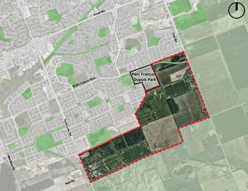
Thank you to those who joined us at the third public open house for the E1 Future Neighbourhood Plan (Wall Road – South Orléans) on Monday, November 17, 2025.
For those who were not able to attend or those who wish to review the material, digital versions of the consultation boards are now available. They can also be viewed by accessing the link under “Documents” on the right of this web page.
If you have any feedback or questions, please continue to contact us at suburb@ottawa.ca. The project teams are reviewing and considering your input on the plan. We are still welcoming comments and questions. If you know others who would like to join the project mailing list, please ask them to email the same address.
We greatly appreciate your participation and valuable input as we continue planning for the future of this community.
Share Public open house #3 - November 17, 2025 (completed) on Facebook
Share Public open house #3 - November 17, 2025 (completed) on X (formerly Twitter)
Share Public open house #3 - November 17, 2025 (completed) on Linkedin
Email Public open house #3 - November 17, 2025 (completed) link
Thank you to all participants who took part in the third public open house for the E1 Future Neighbourhood Plan (Wall Road) at the Aquaview Community Hall, located at 318 Aquaview Drive.
This event presented the area opportunities and constraints, community vision, block plan options and a draft recommended plan. It was an opportunity for the project teams to seek community feedback, and for members of the public and other important stakeholders to ask questions and share your input directly.
Share Public open house #2 – November 28, 2024 (completed) on Facebook
Share Public open house #2 – November 28, 2024 (completed) on X (formerly Twitter)
Share Public open house #2 – November 28, 2024 (completed) on Linkedin
Email Public open house #2 – November 28, 2024 (completed) link
We wish to thank residents for participating in the public open house which was held on November 28, 2024 at the Aquaview Community Hall, 318 Aquaview Drive.
The second public house addressed the existing environmental, infrastructure, transportation and planning conditions that will factor into the community plan.
Digital display boards are available for viewing on the right side of this webpage under "Documents".
Share Public open house #1 – April 8, 2024 (completed) on Facebook
Share Public open house #1 – April 8, 2024 (completed) on X (formerly Twitter)
Share Public open house #1 – April 8, 2024 (completed) on Linkedin
Email Public open house #1 – April 8, 2024 (completed) link
We wish to thank residents for participating in the drop-in public open house which was held on April 8, 2024 at the Aquaview Community Hall, 318 Aquaview Drive.
Digital display boards are available for viewing on the right side of this webpage under "Documents".
We wish to thank residents for participating in the drop-in public open house which was held on April 8, 2024 at the Aquaview Community Hall, 318 Aquaview Drive.
Digital display boards are available for viewing on the right side of this webpage under "Documents".


 E1 - South Orléans - Wall Road - Third open house display boards - November 17 2025 (13.9 MB) (pdf)
