Share Public Open House #3 - July 28, 2026 on Facebook
Share Public Open House #3 - July 28, 2026 on X (formerly Twitter)
Share Public Open House #3 - July 28, 2026 on Linkedin
Email Public Open House #3 - July 28, 2026 link
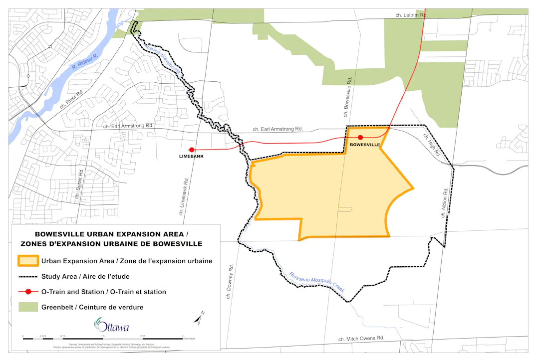
This event will present the area’s existing conditions, opportunities and constraints, and evaluation of alternative solutions, as well as the draft servicing, mobility, and land use plans. It is an opportunity for the project team to share plans for the future of this community and for community members and stakeholders to ask questions and provide feedback.
Details of the event:
Date: Tuesday, July 28, 2026
Time: 6 pm – 8 pm
Format: Presentation at 7 pm
Location: Fred Barrett Arena – Lion's Hall second floor - 3280 Leitrim Rd, Gloucester, ON K1T 3Z4
Share Public open house #2 – October 21, 2024 (completed) on Facebook
Share Public open house #2 – October 21, 2024 (completed) on X (formerly Twitter)
Share Public open house #2 – October 21, 2024 (completed) on Linkedin
Email Public open house #2 – October 21, 2024 (completed) link
We wish to thank residents for participating in the second public open house for the Bowesville (S-3) future neighbourhood development plan (secondary plan) which took place on October 21, 2024 at the Falcon Ridge Golf Club.
The purpose of this event was to learn about the Bowesville area and the secondary planning process. Members of the secondary plan team (City staff and landowners’ consultants) were available to answer residents' questions and took note of their comments.
Share Public open house #1 – April 10, 2024 (completed) on Facebook
Share Public open house #1 – April 10, 2024 (completed) on X (formerly Twitter)
Share Public open house #1 – April 10, 2024 (completed) on Linkedin
Email Public open house #1 – April 10, 2024 (completed) link
We wish to thank residents for participating in the first public open house held on April 10, 2024 at the Falconridge Golf Course (4740 High Road).
We wish to thank residents for participating in the first public open house held on April 10, 2024 at the Falconridge Golf Course (4740 High Road).